Route 6 to see improvements
Route 6 may soon see upgrades, as the Southeastern Regional Planning and Economic Development District (SRPEDD) is working to make the road safer.
The section of Rte. 6 being studied stretches from High Street in Wareham to Rte. 240 in Fairhaven. Between 10,000 and 15,000 vehicles travel the state-owned road each day, most at speeds between 40 and 50 miles per hour.
On Thursday night, the group held a public meeting to share the results of a traffic study, explain potential improvements, and to hear feedback from those who regularly use the road.
According to Jed Cornock, SRPEDD Project Manager, the public’s top concerns included high traffic speeds, pedestrian safety, and lack of bicycle lanes. In 2018, the group held public workshops and received more than 700 responses to a survey about the road.
“The existing conditions that create safety issues on Route 6 include narrow travel lanes, narrow painted shoulder, roadway curves, several angled ‘T-style’ intersections, and issues with the drainage system,” said Cornock.
In Wareham, Cornock said all intersections operate “very well” with the exception of Swifts Beach Road.
SRPEDD gave the Swifts Beach Road intersection the lowest possible score in its evaluation, noting high levels of driver frustration and excessive delays.
“With the signal station at Swifts Beach, your operations improve dramatically, as does the safety in this situation,” said Cornock.
The Swifts Beach Road and Rte. 6 intersection has been the site of many accidents, including three recent accidents in which a pedestrian was struck.
In Marion, the Spring Street intersection requires the most work, according to Cornock. Under the existing conditions, SRPEDD said the intersection causes driver frustration and moderate delays. Because vehicles are typically spaced about 160 feet apart, drivers have trouble changing lanes or passing. In its current configuration, it would not qualify for a traffic light.
Like in Wareham, a proposed additional traffic signal instead of the current stop sign would help traffic move through the intersection more efficiently. Cornock said that the rest of the Rte. 6 intersections in Marion should be able to accommodate traffic through at least 2040.
In Mattapoisett, Cornock said that all of the intersections in function fairly well, although the North Street intersection could see a left-turn only light added.
According to Cornock, the part of Route 6 that goes through Fairhaven and Mattapoisett has the safest sidewalk conditions, with most of the sidewalk being completely new. Going into Marion, the quality of safe sidewalks deteriorates, especially on the section of Rte. 6 intersecting with Converse Road, Main Street, Spring Street, and Front Street.
Wareham has the most dangerous sidewalks from Hermitage Road all the way to the Shaw’s Plaza (Marion Road). The safest sidewalks in Wareham are those between High Street and Gibbs Avenue.
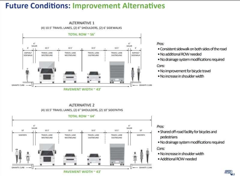
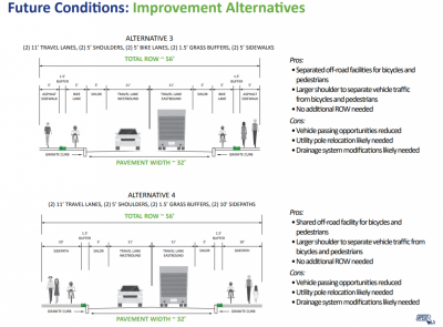
SRPEDD presented four possible designs for Rte. 6 in an attempt to balance the need to accommodate future traffic, improve safety and provide better bicycle and pedestrian facilities. One design could be chosen for the entire stretch of Rte. 6 being considered, or the structure of the road could vary according to traffic needs and the preferences of residents.
The first alternative would include four 10 ½-foot travel lanes, two six-foot asphalt sidewalks and two 6-inch shoulders. This plan would allow for a consistent sidewalk on both sides of the road and wouldn't require drainage system modifications. However, this alternative would neither have a bicycle lane nor an increase in shoulder width.
The second alternative would feature four 10 ½-foot travel lanes, two 10-foot sidewalks and two six-inch shoulders. Unlike the first alternative, it would provide a shared off-road facility for bicycles and pedestrians.
The third alternative would feature two 11-foot travel lanes, two five-foot shoulders, two five-foot sidewalks, and two five-foot bike lanes. This alternative would separate off-road facilities for bicycles and pedestrians and would provide a larger shoulder to separate vehicle traffic from bicycles and pedestrians. But since this alternative modifies the road to only two lanes, vehicle passing opportunities would be reduced. Moreover, the drainage system modification and utility pole relocation will likely be needed.
Finally, the fourth alternative would be the same as the third, but cyclists would share the sidewalk with pedestrians.
During the presentation, residents raised their concerns regarding the implementation of bike lanes, complaining that improvement of the drainage system would cost a lot of money. Others also feared those bike lanes will drastically increase the travel time.
“What would it cost us to get two lanes on Route 6 and bike lanes instead of four lanes for cars?” asked one resident.
Although “it’s difficult to estimate your trip time from one way to another,” Cornock said that implementation of bike lanes would slow down the traffic to 25 to 35 seconds.
Another public meeting discussing the report will be held from 6 to 8 p.m. on Monday, Jan. 6, at the Sippican Elementary School at 16 Spring St. in Marion.
Following the two meetings, SRPEDD will submit a draft report to the towns and MassDOT for feedback, before compiling a final report for MassDOT. While the report was requested by the towns, citing safety concerns, Cornock said that “MassDOT has been an active participant in the process and is looking forward to the final report.”


