Study considers safety on Route 6
A draft study by the Southeastern Regional Planning and Economic Development District recommended a number of changes to Route 6 for safety, including changes to intersections, using LED lighting, better drainage and more visible crosswalks
The survey, which was released on Feb. 19, called Route 6 an “auto-centric, 4-lane highway that prioritizes vehicle use and discourages walking or biking.”
Based on a survey of 13 miles of road, from Fairhaven to Wareham, the planner recommended improvements to both individual intersections and along the highway in general.
The study recommended that the towns and state add signals at Swifts Beach Road and create 90 degree intersections at Hathaway Street.
Other recommendations included using more visible signage, LED streetlights, changing to more visible crosswalk markings, reconstructing drainage to avoid standing water, removing telephone poles from sidewalks to make them handicap accessible, and adding bicycle signage.
The study suggested that these changes be made whether or not Route 6 changes in its configuration.
The study’s authors looked to come to more of a consensus on how residents in all towns would like to see Route 6 changed, and to judge whether residents would favor a two lane highway. The planning study will also serve as an important tool for the towns as they move forward in talking with the state about any changes.
Cornock had previously presented four options for the road (explained here), but rather that choosing one for all 13 miles, wanted to leave it to the towns because they had “a mix of responses. There isn’t a clear consensus about the entire corridor,” said Jed Cornock, the project’s contact with SRPEDD.
He added that some communities feel more passionately about one option or the other, and should contact the state Department of Transportation to make that happen.
To brainstorm new configurations for the road, SRPEDD looked at 32 diagrams completed at informational meetings. Three layouts that had the most consensus and were advanced to Phase 2 of the study.
Meeting attendees preferred a three lane configuration early on, but SRPEDD did not include this option because of safety concerns. Based on state design guides, three lane configurations should have a speed limit of 30 mph, but even the lower end of the range of average speeds clocked in at 36 miles an hour.
Regarding the three lane option, the planner said, “Mass DOT should work closely with the communities to determine if a solution can be engineered.”
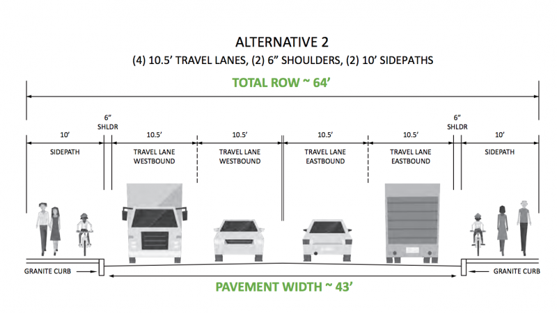
Of the four alternatives that the group presented this winter, the group said “The majority of respondents preferred Alternative #2 — keeping the 4-lane configuration while expanding the existing sidewalks to provide a 10-foot side path on both sides of the road for the entire corridor.”
That majority would be 31% of 113 preference surveys. However, the study authors expressed some concern with that option because it does not address high speeds on the road or narrow travel lanes and will require buying land.
Other miscellaneous findings include pavement quality on road and sidewalks, accident volume and which intersections towns should focus on to fix first.
Pavement was in good condition in Wareham, but sidewalks were in poor conditon.
Shaw’s Plaza in Wareham had an accident rate that was higher than the state average.
The report also ranked various intersections based on their level of service at peak time. Swift’s Beach was the only intersection with a failing grade
Cromesett Rd, Swifts Beach Road, and Gibbs Avenue will have failing grades by 2040 if not improved. Wareham is working to add a signal to Swifts Beach, and will need to explore options for other intersections.
SRPEDD will be accepting comments on the draft study until March 17, 2020. Comments can be emailed to: jcornock@srpedd.org. After finalizing the study, towns will be left to work with the Massachusetts Department of Transportation.


