Flood waters threaten Wareham
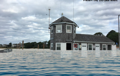
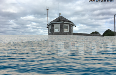
Researchers at the Woods Hole Group took a look at Wareham’s watery future and, on Dec. 19, presented a report on the town’s increasing vulnerability to flooding.
“It really all comes down to climate change,” said Elise Leduc, the project manager. Using historical data and future projections, Leduc explained how different parts of town, including Onset Avenue, the Swifts Beach neighborhood, and Lopes Field are already vulnerable to floods, and that the likelihood of flooding increases each year.
As the earth’s atmosphere warms, so does the ocean, causing sea levels to rise due to the increased space that warmer water molecules take up, compounded by melting sea ice. In recent years, sea levels have been rising faster than ever, Leduc said.
Despite the doubts of some politicians, the warming climate is acknowledged by scientists, insurance rate setters, and the Massachusetts Department of Transportation, data from which was used in the study.
Sea levels have risen more than a foot in the last hundred years, as measured in Falmouth, and are expected to rise up to 7.7 feet higher by 2100. That means that coastal properties will be at risk not only from severe storms, but some areas in town, including many roads in Swifts Beach, will be flooded by virtually every high tide as early as 2050.
While no one knows exactly how high sea levels will climb, those who study climate change are virtually certain that sea levels could rise up to 7.7 feet by 2100, which would be catastrophic to low-lying areas of Wareham. Even at the lowest projected possible sea level rise, Arnold and Cove Streets and Onset Avenue would flood with the tides in 2100, as would many homes in Swifts Beach.
As part of a program to help towns prepare for the effects of climate change, Wareham received a grant to pay for the study, which looked at the vulnerability of various town-owned properties and neighborhoods to flooding through 2100.
Some roads are especially vulnerable.
More than 2,000 feet of Sandwich Road will likely flood daily by 2070. Because there are a number of houses between Sandwich Road and the river, protecting the road from flooding is made more complicated. Simply elevating the road would strand the homes, and building an earthen berm or mound along the road could separate the road from the homes. One potential solution suggested by Leduc would be to build a berm that, where necessary, wraps around the back of homes to protect them and the road from the tide.
Large sections of Main Street and Merchants Way will also be flooded by high tide by 2070. One potential solution would be to build a terraced wall between the river and Merchants Way to protect the roads and businesses. The railroad bridge and the Narrows Bridge would also need to be elevated. Leduc noted that the water regularly reaches the bottom of the Narrows Bridge, demonstrating that the sea level is already too high for the current bridge.
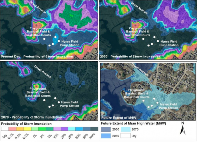
About 1,200 feet of Onset Avenue will flood daily by 2070. Leduc noted that the road is very vulnerable to flooding even today, with a fifty percent chance of flooding each year. The road could be elevated in sections by building a causeway, and side streets might also need to be elevated. Because Onset Avenue is one of only three roads in and out of Onset, keeping it usable is an especially high priority. Along with the road, Lopes Playground, along with the baseball field and basketball courts, will be intertidal. The Lopes Park area could, in time, transition to salt marsh.
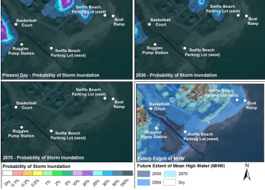
Swifts Beach is especially vulnerable because the land is almost completely flat from the water’s edge, to the parking lot, to the neighborhood. There is also a creek that begins near the beach and extends into the neighborhood, which could overflow with the tides as early as 2030.
“There’s nothing to stop flood-water from coming in through this neighborhood during a storm today,” Leduc said. She recommended building up a vegetated coastal dune, which would not stop flooding, but would protect the buildings from the force of the waves. The basketball court and playground will be flood at high tide in 2050, as will some homes in 2070.


