Residents voice concerns at Route 6 redesign hearing
The state is forging ahead with plans to reconstruct a section of Route 6 from a point east of Cromesett Road to Town Hall to have only one travel lane in each direction. At a Wednesday, June 21, virtual public hearing on design plans, a number of residents expressed concern about the scheme, with one calling it “a potential nightmare.”
The plans presented at the hearing are the latest development in a long-running conversation about how to reconstruct a large stretch of the state highway along the South Coast.
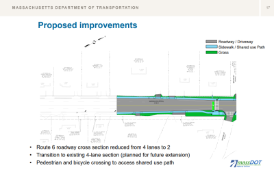
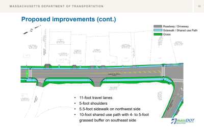
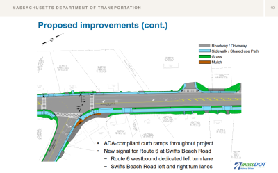
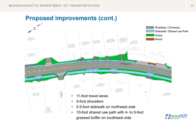
As presented by a team from the Massachusetts Department of Transportation and consulting engineers from Tetra Tech, the redesigned roadway would be reduced to two travel lines with 5-foot shoulders, a “shared use” bike lane, a left-turn lane heading eastbound from the Shaw’s plaza to Gibbs Avenue and a left-turn lane heading westbound onto Swifts Beach Road.
Additionally, the project would include the installation of a new traffic signal at the Swifts Beach Road intersection and ADA-compliant curb ramps. The traffic signal at Shaw’s plaza would receive an upgrade. The speed limit would be 35 miles per hour.
Crosswalks will be placed across Route 6 at Brown Street, Swifts Beach Road, Longmeadow Drive, Glenda Avenue and Viking Drive. Each street off of Route 6 in this section will receive a crosswalk to connect the sidewalks.
During construction, the road would still be open to one-lane traffic in both directions, according to Jim Antonizick, a project manager from Tetra Tech. And businesses and residential areas would still be open and accessible.
Antonizick could not give a cost estimate for the project, but said projects of this size typically cost around $5 million. Eighty percent of the project’s funding would come from the federal government and the other 20% from the state.
Safety concerns for the roadway as it currently exists were highlighted in the Southeastern Regional Planning & Economic Development District’s Route 6 “corridor study.” A corridor study is used to identify the level of access and mobility a roadway provides and what improvements should be made to meet the needs of residents.
Antonizick said reducing the number of lanes and adding a traffic signal would match the existing and projected traffic volumes and improve safety.
Select Board Clerk Tricia Wurts was skeptical about the analysis, saying that it took place during the Covid pandemic when far fewer people were on the roads.
Antonizick said the analysis included data from before the pandemic, and took summer traffic into consideration.
Patangay Soni, a project manager for Tetra Tech, said school traffic and buses were also considered when collecting the traffic data.
Wurts was also concerned about storms and flooding, especially on behalf of the two larger neighborhoods — Swifts Beach Road and Cromesett Road — off of Marion Road. When these neighborhoods have an emergency situation, the only evacuation route for residents is Marion Road because of the water that surrounds them.
Other attendees shared similar concerns about the reduced number of lanes.
“This is a potential nightmare,” an anonymous attendee said. “We need an additional road in and out, not less lanes.”
Antonizick said Wurts and the other attendees’ concerns will be taken under consideration.
Attendees shared concerns about how this project would affect the environment: “So much for being environmentally friendly!!” An anonymous attendee wrote in the chat.
“Making it one lane in each direction will be bad for the environment, since traffic will be backed up,” another anonymous attendee said.
Antonizick said the shared-use path will encourage people to use other modes of transportation, which can reduce pollution.
Attendee Karen Storey, whose mother is a Wareham resident, wondered what would happen to the trees and shrubs on her mother’s property that are close to the road.
Antonizick said the curb lines would be brought more into the street, and cars would be pushed further away from property lines. However, installing the shared-use path may damage roots, which would require the shrubs and trees to be removed. This would be decided on a case-by-case basis.
MassDOT would be responsible for acquiring rights on public and private lands, he said. Affected property owners would be contacted.
Antonizick said the next step for this project is to review and consider any responses it receives. Then, by the end of this summer, 75% of the design package will be submitted to MassDOT for review.
The full design will be submitted for review by the end of 2023. The plans, specifications and cost estimate will then be submitted for final review by spring 2024.
By winter 2024, the project will begin to be advertised, a contractor will be selected and construction will begin, Antonizick said.
Any additional comments residents may have can be emailed to massDOTProjectManagement@dot.state.ma.us.


