Town in compliance with MBTA community regulations
Wareham is in compliance with the new regulations that require communities around Massachusetts Bay Transportation Authority stations to adopt a multi-family housing district within a half mile of their public transit station, according to Director of Planning and Community Development Ken Buckland.
While Wareham doesn’t have a commuter rail station, it does achieve the status of a “MBTA adjacent” community due its close proximity to Middleboro’s station.
This status requires Wareham to meet a number of zoning guidelines that promote the development of multi-family housing. According to Buckland, the town has an existing “general commercial” zoning district that meets all of those guidelines.
According to the law, the multi-family housing district in Wareham must allow for the development of 1,297 multi-family housing units — with no age restrictions — in a minimum land area of 50 acres. These figures are based on 10% of the town’s total housing units.
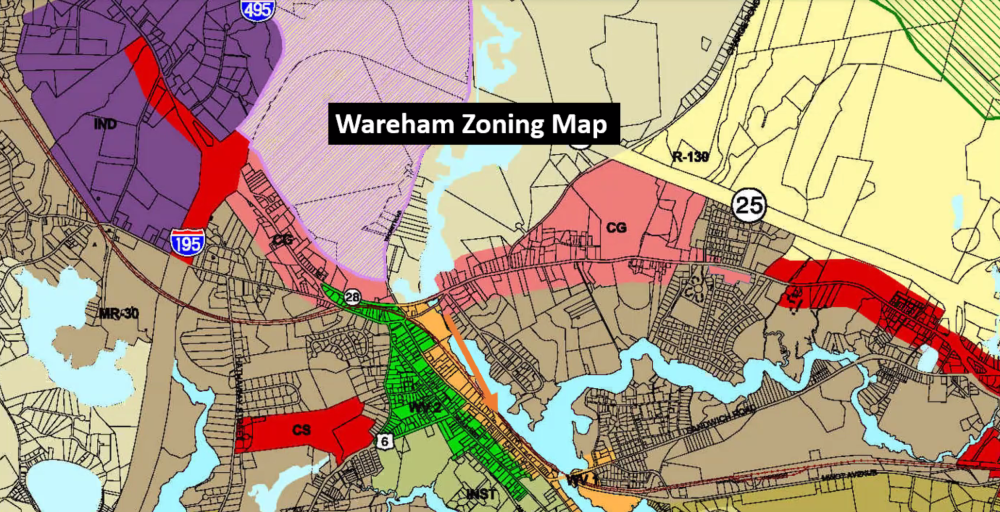
The “general commercial” district, which is 306.5 acres with two-thirds of the land available for development, has the potential for 3,606 multi-family housing units, he said. This would also meet the population density requirement of 15 units per acre with a possible 16.6 units per acre.
The housing units do not need to be constructed, Buckland said. The purpose of the zoning guidelines for this multi-family housing district is to make development of these units easier to achieve in the future within the context of Massachusetts’ ongoing housing crisis.
“There's no production necessary under this program,” Buckland said. “It's going to follow the market demands that come along with housing demands that we'll see within the community.”
Buckland said while other communities have to sort out their zoning district with a risk of noncompliance leading to lawsuits or loss of state funding eligibility, Wareham is all set.
The defined district is split in two sections that meet at the south end of Parker Mills Pond at the dam. The approximate location of the section to the west is the land running along both sides of Cranberry Highway up to I-195. The section to the east is bordered by Charge Pond Road from the left, Route 25 from above and Willard Street from the right. The bottom of the section extends a little past the south side of Cranberry Highway. (See the salmon-colored sections of the zoning map.)


