Town plans for Main Street's future
Over the summer, the town formalized its recommendations for the long term success of Main Street in two documents: a Resilient Main Street report and a draft Downtown Urban Renewal plan.
However, it may take five years or more before the recommendations in those documents start to re-shape the landscape of Main Street.
The Resilient Main Street report, drafted in June, focuses on Main Street's vulnerability to the effects of worsening flooding due to rising sea levels.
The report is a "long term look at what the future might be on Main Street,” said Ken Buckland, director of Planning and Community Development.
Major flooding events on Main Street will reach higher and higher elevations over the next few decades, according to the report.
Buildings on lower Main Street, closer to Tobey Hospital, will experience the worst of the flood damage, as the terrain there is closer to the water level. Within 50 years, even normal high tide conditions may become a flood hazard in that area.
Further up Main Street, closer to the Wareham Fire Department station, the damage won't be as severe.
These findings informed the recommendations contained within the Urban Renewal Plan.
The Urban Renewal Plan outlines the steps the town and the Wareham Redevelopment Authority can take to revitalize and beautify Main Street. A draft of the plan was completed in August.
Buckland said the plan may inspire more private investment in properties along Main Street over the next couple of years.
This private investment could clean up Merchants Way, renovate existing buildings and bring more activities, stores and events to the downtown, he said.
The zoning changes passed by town meeting in April were part of the plan’s recommendations. These changes increased the allowable building height on Main Street and Merchants Way from 40 to 50 feet, and to 65 feet in special cases approved by the Planning Board, and increased the allowable density of development on Main Street and Merchants Way.
The plan outlines several major projects for the town, including:
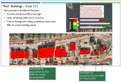
- The Redevelopment Authority may purchase certain buildings on Main Street, including 195 and 203 Main Street, and demolish them, replacing them with flood-resistant construction.
- The Authority may also purchase buildings on lower Main Street and demolish them to create a "sponge park," an open, green area that can absorb the worst of the floodwaters.
- The town may create a boardwalk along Merchants Way, attached to the rear of Main Street businesses. This boardwalk may be elevated to allow for parking beneath it and to elevate retail space above projected flood levels.
- The town may also create a riverside boardwalk and pier running along the train tracks by Merchants Way and connecting to the Tremont Nail Property.
While the town will acquire some Main Street buildings under this plan, particularly to create the sponge park, Buckland said he expects this to happen naturally — if storms continue to hit the town, people will want to sell their property or abandon it, leaving it vacant for the town to redevelop as an open space that protects the rest of Main Street.
The plan anticipates that mixed-use development will increase in areas away from Main Street, particularly along Center Street.
While the plan has been drafted, it still needs approval from the Planning Board and from the state government to take effect.
The Planning Board has not yet discussed the plan, said Planning Board Member Sam Corbitt.
Even once the plan is adopted, the timeline for its completion reaches five to 20 years into the future. Only after at least three years of conversations with property owners and state agencies could the town begin to acquire properties and build out the boardwalks, according to the plan's timeline.


